


Southeast Asia Space Roundup: 3 to 9 April 2025
A summary of all the space news in Southeast Asia over the past week, brought to you by AzurX

")
The following are the major space developments in the Southeast Asian region tracked by Southeast Asia Space Monitor over the past week:
Thailand Space Developments
Thailand and India Elevate Ties to Strategic Partnership, Space Cooperation Emphasized
Thailand and India have elevated their bilateral relationship to a strategic partnership, with a renewed emphasis on space cooperation among other advanced technologies. During talks between Prime Minister Narendra Modi and Thai counterpart Paetongtarn Shinawatra, both countries agreed to deepen collaboration in key innovation sectors, including space, robotics, digital technology, and biotechnology, as part of a broader push to strengthen regional security and economic connectivity in the Indo-Pacific. Modi underscored shared interests in peace, stability, and development—distinct from expansionism—in a region increasingly wary of Chinese assertiveness. The announcement includes plans to boost cooperation between Indian and Thai security agencies, expand renewable energy and startup engagement, and improve FinTech and physical connectivity. The strategic dialogue and space cooperation commitments align with India’s Act East Policy and Indo-Pacific vision, reflecting growing recognition of satellite and space technologies as essential tools for economic development, national security, and regional influence.
")
At BIMSTEC Summit in Thailand, PM Modi Proposes Space Cooperation Between Member States
At the 6th Bay of Bengal Initiative for Multi-Sectoral Technical and Economic Cooperation (BIMSTEC) Summit in Bangkok, Thailand, Indian Prime Minister Narendra Modi emphasized the critical role of space cooperation and satellite applications in advancing the grouping’s collective development and security agenda, unveiling a 21-point action plan that includes significant space-related initiatives. Among the proposals, Modi called for the development and launch of nano-satellites, the use of remote sensing data to support regional development, and the establishment of a ground station to facilitate manpower training—steps aimed at deepening BIMSTEC’s technological and geospatial capabilities. These initiatives align with the broader BIMSTEC Bangkok Vision 2030, which envisions an integrated and resilient regional framework that leverages digital and space-based infrastructure to enhance connectivity and human security. The summit also saw the adoption of maritime transport cooperation agreements and procedural rules to strengthen regional integration, with satellites and space data positioned as key enablers for improved logistics, disaster management, and sustainable development. Modi’s announcement signals India’s intent to elevate BIMSTEC’s space capabilities as a pillar of regional collaboration, offering both strategic and economic benefits to member states. BIMSTEC is comprised of Bangladesh, Bhutan, India, Myanmar, Nepal, Sri Lanka, and Thailand.
 and Thai Airways Strengthen Partnership to Equip 80 Aircraft with Advanced In-Flight Connectivity")
Thailand’s Thai Airways Deepen’s Partnership With Saudi Arabia’s Neo Space Group for SATCOM Inflight Connectivity
Saudi Arabia’s Neo Space Group (NSG) has deepened its partnership with Thailand’s Thai Airways to equip 80 aircraft with its advanced In-Flight Connectivity (IFC) system, leveraging SES’s Open Orbits™ multi-orbit satellite network, which combines GEO and MEO satellites for high-speed, low-latency global coverage. This IFC upgrade, delivering speeds up to 200 Mbps, will offer unlimited Wi-Fi to passengers—including streaming for premium class and Royal Orchid Plus® members—starting with retrofitting Boeing 777s in Q3 2025, followed by line-fitting Airbus A321neos and Boeing 787s with HBCplus and Aeroconnect platforms. Integrating Display Interactive’s Skywaves® and SkyFly systems, the solution enhances digital passenger engagement and operational efficiency, positioning Thai Airways as a leader in connectivity-driven customer experience. This strategic move reflects the airline’s broader commitment to digital transformation and NSG’s growing influence in satellite-enabled aviation services across Asia-Pacific.
Myanmar Space News
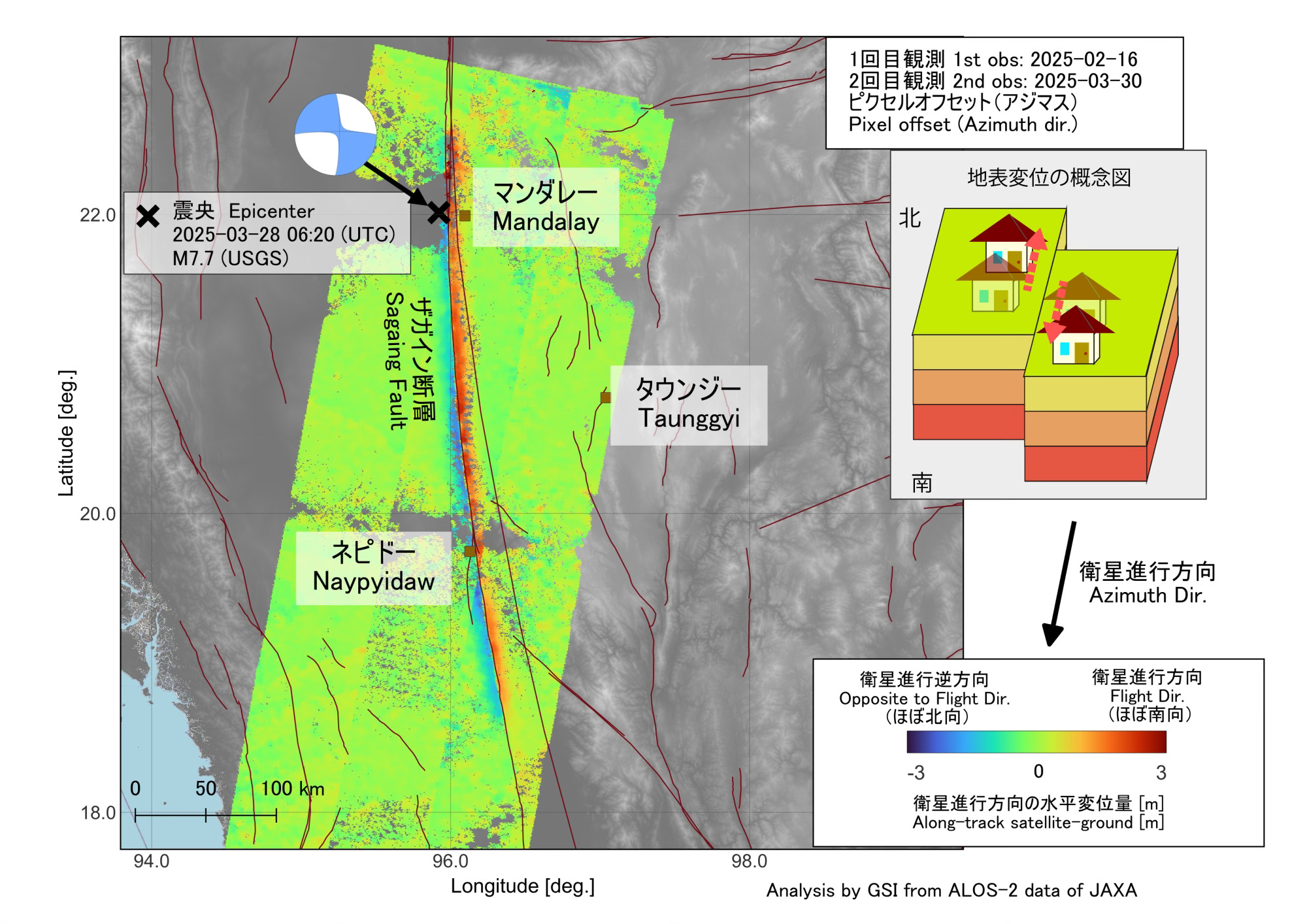
Japanese Satellites Reveal Scale of Myanmar’s Earthquake Devastation
Japan’s Geospatial Information Authority (GSI) has revealed that satellite-based Earth observation analysis detected significant crustal displacement along a 400-kilometer stretch of Myanmar’s Sagaing Fault following the recent magnitude 7.7 earthquake. Using high-resolution data from one of Japan’s Earth observation satellites, GSI determined that the ground shifted up to six meters—northward on the western side and southward on the eastern side—highlighting the immense tectonic energy released. This scale of slippage, far exceeding that of Japan’s 2016 Kumamoto earthquake, underscores the strategic value of satellite geospatial capabilities for post-disaster assessment and risk analysis. GSI officials noted that similar inland fault structures exist in Japan, implying critical lessons for preparedness. The episode reaffirms the indispensable role of satellite-based geospatial monitoring in understanding seismic events, informing infrastructure resilience planning, and supporting rapid-response mechanisms across tectonically active regions.
In Myanmar Earthquake Response, China’s Satellites Dominate in Post-Disaster Monitoring
The devastating 7.9-magnitude earthquake in Myanmar has become a showcase for China's rapidly advancing satellite capabilities and their geopolitical utility. In stark contrast to the delayed U.S. response, China swiftly deployed 14 satellites from the China Aerospace Science and Technology Corporation (CASC) to map disaster zones, identify collapsed infrastructure, and guide humanitarian logistics with precision. These satellites provided real-time imagery to support the rescue of survivors and coordinate relief delivery, underscoring China’s capacity for rapid orbital adjustments and coordinated space operations. The U.S., by comparison, offered limited aid and lacked satellite-driven emergency engagement, drawing criticism over shrinking USAID capacity. This disparity has elevated concerns in Washington about China’s growing soft power and satellite superiority, especially given the potential dual-use nature of the space assets in both humanitarian and military contexts. Analysts suggest China’s satellite operations in Myanmar may signal a strategic shift, reinforcing its influence in a geopolitically critical region and challenging the long-standing U.S. advantage in space-based surveillance and response infrastructure.
Philippine Space News
Philippine Navy Calls for Maritime Domain Awareness, Emphasizes Satellite Solutions
Rear Admiral Roy Vincent Trinidad of the Philippine Navy emphasized the urgent need to enhance the country's maritime domain awareness (MDA) capabilities, particularly through the integration of air, land, sea, and space-based platforms, to effectively conduct comprehensive archipelagic defense operations. Speaking at Camp Capinpin, Trinidad underscored that space-based surveillance systems are critical for monitoring activity across the Philippines’ extensive maritime territories, including its exclusive economic zone (EEZ), which saw over 15,000 vessels—primarily foreign—tracked in March alone. Notably, satellite and aerial reconnaissance tools play a pivotal role in detecting incursions, such as the presence of multiple People's Liberation Army Navy (PLAN) and China Coast Guard (CCG) vessels in disputed areas like Bajo de Masinloc, Ayungin Shoal, and Sabina Shoal. The Philippine Coast Guard's recent tracking and challenging of foreign research ships further highlighted the importance of coordinated space-enabled situational awareness in securing national waters. The Armed Forces of the Philippines’ (AFP) continued investment in space technologies reflects its strategic priority to leverage satellite intelligence for sovereignty enforcement and regional stability in the West Philippine Sea.

Philippine Space Agency Hosts EU Delegation, Discusses Collaboration on Earth Observation
The Philippine Space Agency (PhilSA) recently hosted a high-level delegation from the EU Council of Asia-Pacific Working Party (COASI) and the European Union Delegation, marking a significant milestone in the Philippines-EU collaboration on space-based technologies. Central to the visit was the National Copernicus Capacity Support Action Programme for the Philippines (CopPhil), the EU's flagship initiative under its Global Gateway strategy. CopPhil leverages data from the EU's Copernicus satellite system to support critical applications such as disaster risk reduction, environmental monitoring, and climate change adaptation. With the inauguration of Southeast Asia’s first Copernicus Data Centre in October 2024 and the rollout of Earth observation pilot services—including land cover mapping, coastal monitoring, and ground motion tracking—the initiative is accelerating the country’s integration of satellite-derived insights into national planning. PhilSA, in partnership with the European Space Agency (ESA) and the Department of Science and Technology (DOST), is also investing in capacity building through training and scholarships to bolster local expertise in Earth observation. This effort positions the Philippines as an emerging regional hub for satellite applications in Southeast Asia, underscoring how international cooperation can transform satellite data into actionable outcomes for sustainable development.
Other Regional Space Developments
Starlink in Vietnam: Satellite Network May Not Gain Mass Adoption
Vietnam has approved a five-year trial for SpaceX’s Starlink low Earth orbit (LEO) satellite internet service, capped at 600,000 subscribers and subject to national security and defense regulations, with operations to end before 1 January 2031. With an estimated investment of $1.5 billion, Starlink aims to bridge the digital divide in underserved areas by supporting education, telemedicine, and disaster response. SpaceX is working with Vietnam's Ministry of Science and Technology to establish a local entity and a ground gateway station by year-end. Despite Vietnam’s high internet penetration, gaps remain—especially in remote regions where fiber-optic infrastructure is lacking and three of six undersea cables are aging. While traditional telecom operators express concern about competition, experts argue Starlink will complement rather than replace terrestrial networks, offering coverage in geographically challenging areas. However, the high initial and subscription costs, coupled with weather sensitivity, may limit mass adoption. Industry leaders see Starlink's entry as a catalyst for improved service quality and broader coverage, especially in Vietnam’s more isolated regions.

Leading Singapore SAR Satellite Researcher to Give Keynote Address at Australian Space Summit
At the upcoming Australian Space Summit & Exhibition 2025, Sang-Ho Yun, director of the Earth Observatory of Singapore’s Remote Sensing Lab, will deliver a keynote address highlighting the transformative role of next-generation Synthetic Aperture Radar (SAR) technologies in satellite-based disaster monitoring and climate resilience. With over 15 years of experience supporting more than 200 global disaster response operations—including for Typhoon Haiyan, the Türkiye-Syria earthquake, and the Beirut explosion—Yun will detail how SAR and Interferometric SAR (InSAR) are revolutionizing emergency response through cloud-penetrating, day-and-night satellite imaging. His insights will focus on operational integration of SAR data for applications such as urban flood mapping, sustainable agriculture, and rapid post-disaster assessments. Drawing from his previous work at NASA’s Jet Propulsion Laboratory and his current leadership at Singapore’s Earth Observatory, Yun will also emphasize the strategic value of stable national infrastructure for continuous SAR-based monitoring and international collaboration. His keynote underscores the growing importance of space-based remote sensing in global crisis management and geospatial decision-making frameworks.
Malaysia’s MEASAT Honored as Hybrid Teleport Operator of the Year
At the 2025 Teleport Awards for Excellence, hosted by Network Innovations Advanced Networks, neXat, and Calian, the World Teleport Association (WTA) honored MEASAT as the Hybrid Teleport Operator of the Year. Recognized for its pivotal role in satellite communications across the Asia-Pacific region, Malaysia-based MEASAT delivers a broad portfolio of services through its MEASAT-3b and MEASAT-3d satellites at the 91.5°E orbital slot. The company supports more than 20 million Direct-To-Home TV viewers while also providing high-speed broadband, cellular backhaul, and enterprise connectivity for clients in government, telecom, maritime, oil and gas, and SME sectors. This award underscores MEASAT’s leadership in integrating satellite and terrestrial infrastructure to offer versatile, high-reliability communications solutions in one of the world’s most dynamic digital markets.

UK’s Space Intelligence Reshaping Forest Carbon Credit Landscape in Indonesia
UK-based Space Intelligence is reshaping the forest carbon credit landscape by harnessing advanced satellite technologies and machine learning to provide rigorous, scalable, and verifiable carbon sequestration data—an innovation poised to restore confidence in nature-based carbon markets. Founded by Professors Ed Mitchard and Murray Collins, veterans of ecological fieldwork in Africa, the company capitalizes on publicly available synthetic aperture radar (SAR) and LIDAR satellite data to overcome the inefficiencies and credibility issues long associated with manual forest surveys. Their expertise and proprietary modeling techniques offer a competitive edge in a growing market of remote sensing providers. With $7 million in new venture funding and a strategic partnership with Intercontinental Exchange (ICE), Space Intelligence is now supplying forest baseline data critical for compliance with the EU’s impending deforestation regulation (EUDR), particularly in commodities like cocoa and coffee. The firm is also a trusted partner of carbon credit registries, supporting baselining and verification efforts in key Southeast Asian markets including Indonesia. As tropical forests remain vital carbon sinks, preserving them through credible carbon credit systems is not only an environmental imperative but a financial opportunity—and Space Intelligence stands at the forefront of that transformation.
Be sure to catch up with space activities in the region in the next edition of Southeast Asia Space Monitor’s space roundup!